Wildfire planning

We Help Communities Prepare For Wildfire.

 
The Ember Alliance offers wildfire planning, modelling, facilitating, research, and implementation services to organizations of all sizes. 

Planning

Community Wildfire Protection Plans (CWPPs) are planning processes for adapting communities to a world where wildfire is inevitable.

It brings together all the local stakeholders and residents to understand what is most important in the community, then maps those values against predicted fire behavior in different scenarios, and then makes a plan to address the riskiest and more vulnerable areas over the following five years. 

View our most recent CWPPs here.

The process of creating a CWPP helps communities better understand the risks they face, talk with each other, and make a plan to reduce their risks.

There are federal regulations on CWPPs, and many states have additional requirements for CWPPs in their state. 

Wildfire Risk Assessments (WRAs) are planning documents that address the risk of wildfire and the related hazards in an area. These can be as simple as modelling fire behavior in an area to see where the riskiest locations are, or as complex as addressing fire, flooding, debris flows, avalanches, smoke impacts, evacuations, economic impacts, and more. 

These are variable and customizable documents, depending on your needs. They can follow a Quantitative Wildfire Risk Assessment (QWRA) model as well. 

Forest Management Plans (FMPs) look at a landscape with forests on it and assess the history of management and fire in the area, the needs of the community or landowners, and the goals for that forest. 

Then we write a plan for managing the forests with goals from 5-30 years out. This can include fire mitigation as well as forest health with diseases and insects, climate change, recreation, development, and timber sales. 

These plans focus on a smaller area of forests or fuels that have been identified for treatment.

We work with you to identify the treatment goals then write a prescription for that stand that you or your contractors can follow to reduce the fuel load and risk in that area. 

Understanding what your fire protection district or county can manage in response is the first step in knowing how to improve and where to spend limited funds. 

District capacity assessments analyze the local district’s ability to respond to wildfires and the wildfire risk they face. This can show response times, fire sizes at expected response times, and anticipated response needs based on response location. 

Preparing for a prescribed burn can be a years-long process. The Ember Alliance is experienced in writing and supporting the implementation of prescribed burns.

Whether you are looking to burn 10 acres or 10,000 acres, TEA can help you plan the burn and meet the local requirements for implementing it. 

Do you have a planning effort, assessment, or research project that isn’t in this list? Please reach out to us – this list is not exhaustive and we like to take on new projects and new partners. 

Modelling

We use the best data available and pair it with weather conditions from your community from the past 20 years to model fire behavior under a variety of weather and wind conditions. 

Using modelled fire behavior and structure data, we can evaluate the risk posed to structures by fire in the vegetation in and around the community, as well as the risk of embers from burning homes igniting other homes in the area. 

We model community evacuation scenarios assuming fires may approach from different location and cut off different egress routes. 

We can understand differences in evacuation times and congestion on the roads to inform roadway treatments. 

Following the 2018 Camp Fire, we evaluate road safety for evacuees and incoming firefighters. Areas that are potentially non-survivable are highlighted and incorporated into project priorities. 

Together with the community and stakeholders, we identify and map all the community values, including FEMA community lifelines as well as local values that are not included in national datasets. 

We analyze the wildfire risk to these values and prioritize treatments based off that analysis. 

We can complete this in a Highly Valued Resources and Assets (HVRA) framework as well. 

The effects of fire do not end once the flames are extinguished. Post-fire debris flows, flooding, mudslides, and erosion are serious threats to life and safety and can be addressed in wildfire plans. 

We model post-fire erosion and sediment delivery and assess the history and future impacts of post-fire flooding in order to help communities prepare for and mitigate the risk of those events. The last thing a community needs after a wildfire is another natural disaster. 

Districts facing wildfire response, especially in populated areas, need tools to plan, prepare, and coordinate action when starting an initial attack or preparing further suppression efforts. 

Strategic and tactical maps house all the relevant information in the district in one set of maps that all responders could have access to. This typically includes water sources, gates with codes, lookout points, emergency evacuation routes, potential holding points, and other valuable operational information. 

Some districts have a very solid idea of what their response capacities are, and some do not. We assess the district’s capacity to respond to wildfires through mapping and modelling fires and response times and assess district needs through interviews and research. 

We help districts plan for what equipment they need to acquire, where they should train, and what areas of their district they should be most prepared for more aggressive initial attacks at. 

Smoke is frequently one of the priority issues around wildfire that communities have. We model smoke distribution and impacts of fire and prescribed burns, and make recommendations and educational materials based on the findings. 


Communicating all these technical plans, events, models, and research is not easy. We help districts, counties, and communities share wildfire planning information in an accessible, interactive, and fun way using tools such as ArcGIS Storymaps. 

These Storymaps have become the industry standard for communicating spatial data and are frequently part of the plans we build. 

Do you need an assessment or model that isn’t presented here? Our team is always interested in learning new models, building skills, and turning models and research into actionable outcomes. 

Facilitating

We guide your community, district, or county through the entire CWPP or other planning process from start to finish. We can:

  • Craft a scope of work that meets your needs
  • Schedule and host team meetings
  • Model and analyze fire behavior and risk
  • Facilitate conversations around risk, prioritization, and implementation
  • Identify and connect with partners stakeholders
  • Plan and host community engagement events
  • Write a CWPP or other document that meets or exceeds your state standards

If you want to do some of the planning process work and need help with a single or multiple parts, we can step in where you need. 

We can do anything from facilitating a single meeting to mapping the process to co-facilitating with your organization. 

Working with stakeholders can be simple or difficult, depending on the landscape you live in. TEA specializes in building relationships between stakeholders like utility companies, fire departments, large private landowners, federal agencies, and community groups. 

We can connect with the partners you want to engage and bring them to the table with meaningful, productive discussions. 

Getting community feedback is essential to a planning process. We can design, help distribute, and analyze the results of surveys, community meetings, and focus groups. 

The core team or decision makers take this and use it to inform their decisions about where to work on mitigation. 

Sharing the process and results with the community is how you take a plan from paper to on-the-ground action. 

Connecting with the community early in a planning process and at the end is important to making something that they feel empowered to use.


We can help your plan’s implementation committee coordinate follow-through on the projects. This can involve facilitating meetings, connecting the community with contractors, hiring TEA crews to complete mitigation work, writing burn plans, and tracking project successes. 

This is highly variable between communities and is personalized for each communities need. 

TEA has field crews that can complete mitigation work on private and public lands. From mitigating in the home ignition zone 3 to landscape scale fuels treatments, we can work with communities members or leaders to mitigate risk. 

Pile Burn cooperatives are new to Colorado and TEA can offer support to communities looking to start their PBC or train locals in safe and effective pile building and burning. 

TEA hosts NFPA Certified Wildfire Mitigation Specialists who can assist in on=the-ground hazard assessments for communities, major landowners, governments, and more. 

Do you have work that isn’t listed in here? We may be interested in working with you – reach out and let us know what your needs are. 

Community Engagement Is The Key To Community Preparedness

We don’t build plans that just sit on shelves. We believe passionately in working with a wide variety of partners to build support and trust in your planning process, and to bring diverse perspectives into the problem solving process.

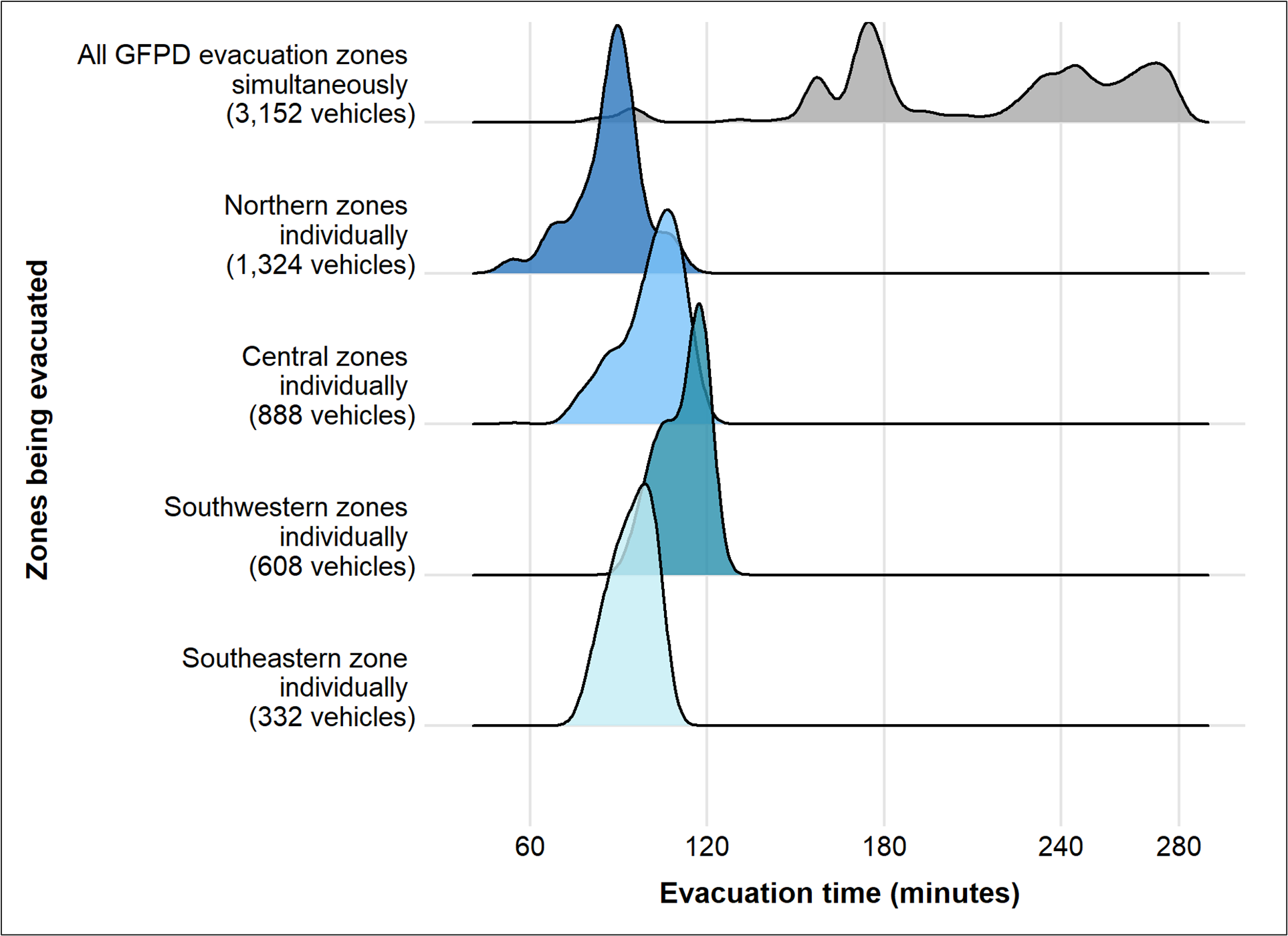
Engagement builds trust and drives action. Throughout the process, community members and stakeholders learn about the risks they face and how they can address them. Research shows that if we can break down mitigation actions into more discrete, tangible steps, people are more likely to take action.

Building New Analyses To Support Emerging Challenges

Communities are exposed to bigger, more intense wildfires. We build better tools to help them prepare for this reality.

Structure Exposure To Wildfires

Science tells us that embers ignite structures much more frequently than fire burning across the surface. Using peer reviewed research, we model how structures – homes, business, and other critical infrastructure – are exposed to embers. This helps communities understand where structures are most likely to be lost during wildfires and prioritize action.

Evacuation Safety

Safe and timely wildfire evacuations are critical for communities in the WUI. Districts need to know where evacuations can and will take longer due to the congestion of mass exoduses, and where roadways may be unsafe for the evacuating residents and incoming firefighters. This helps us know

Finding The Right Fuels Treatment For The Right Place

Fuels treatments help modify fire behavior to improve wildfire suppression outcomes. We combine practical knowledge with fire behavior modeling to identify where to place fuel treatments and what kind of fuel treatments are necessary. Our depth of experience in fuel treatments, from thinning to prescribed fire, combined with our modeling skills will help communities maximize their fuels treatment budgets.


Interested In Working With Us To Bring A Next Generation CWPP To Your Community?

Reach out. We’d love to hear from you.